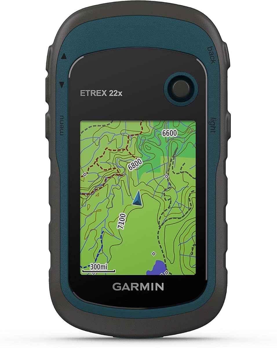
Garmin eTrex 22x
4.3Editor score
Sunlight-readable color display
Topo Active maps included
25-hour GPS battery life
A hunting GPS handheld should remain readable, dependable, and easy to operate across cold mornings, dense timber, steep terrain, and long stretches without cellular service. The right model combines accurate positioning, useful topographic maps, durable construction, extended battery life, and controls that remain manageable with gloves or wet hands.
This guide compares 10 Garmin hunting GPS handhelds, ranging from compact, battery-powered eTrex models to touchscreen devices with advanced satellite positioning and ballistics features. The evaluation considers mapping, display readability, navigation sensors, satellite support, battery endurance, water resistance, outdoor durability, and practical hunting functions.
Each pick reveals where it stands out and where compromises may matter, helping readers match a navigator to their terrain, hunting style, and expected level of detail. Product availability and pricing can change, so shoppers should verify current listings and confirm their preferred maps and accessories before purchasing.
4.3Editor score

4.5Editor score

4.6Editor score
As an Amazon Associate we earn from qualifying purchases.
The comparison below highlights the major differences in positioning, mapping, displays, sensors, power management, and durability. It is designed to show which handheld best fits a particular hunt rather than treating every outdoor enthusiast as having identical navigation needs.




The Garmin eTrex 22x combines a rugged, uncomplicated design with enough mapping and satellite capability for many hunters. Its 4.3 rating reflects a generally favorable user reception, while its compact proportions and physical button layout make it especially approachable. It is a practical choice for hunters who want topographic information without a large touchscreen or complex feature set.
We may earn a commission when you buy through this link, at no additional cost to you.
The 2.2-inch sunlight-readable color display provides 240 by 320 pixels, which is adequate for reading terrain, trails, roads, and route lines. Topo Active maps arrive preloaded with routable roads and trails for hiking and cycling. Support for both GPS and GLONASS improves positioning options in challenging environments, and 8 GB of internal memory plus a microSD card slot offers room for additional map downloads.
Its main limitations are size and sensor equipment. The display is small compared with the larger touchscreens in this guide, and the eTrex 22x does not list an electronic compass or barometric altimeter. That means it is better suited to hunters who prioritize route navigation, mapping, and familiar button operation than those who need a dedicated directional sensor for field use.
The eTrex 22x is a strong recommendation for budget-conscious hikers, general hunters, and backcountry users who value battery life and simplicity. Two AA batteries can provide up to 25 hours in GPS mode, making it practical for multi-day outings when power is managed carefully. Choose this model when reliable mapping and rugged portability matter more than a large screen or advanced ballistic tools.
Preloaded Topo Active maps, routable trails, and expandable storage make the eTrex 22x useful beyond a simple waypoint locator. Hunters can review terrain and roads across a broad hunting area without depending on continuous cellular connectivity.
The button-based interface reduces the learning curve and remains easier to operate with cold or gloved hands. It also avoids accidental touch inputs that can occur when a wet screen is being manipulated.
We may earn a commission when you buy through this link, at no additional cost to you.
The Garmin GPSMAP 65 stands out for hunters who need confident positioning in difficult terrain. Its 4.5 rating is the second-highest among the rated models in this guide, and its expanded GNSS support and multi-band technology address one of the most important navigation challenges in remote hunting country. The device also offers a larger screen than the compact eTrex units.
We may earn a commission when you buy through this link, at no additional cost to you.
The 2.6-inch sunlight-readable color display provides a balanced view of terrain information without making the handheld unnecessarily large. Multi-band technology and expanded global navigation satellite systems are intended to improve accuracy in steep country, urban canyons, and forests with dense trees. Routable TopoActive mapping is included, along with a federal public land map for the United States.
The GPSMAP 65 also works with the Garmin Explore website and app when used with a compatible smartphone, helping users organize tracks, routes, waypoints, and field statistics. Its physical controls are a sensible choice for wet, cold, or glove-covered conditions, although the lack of a touchscreen means less direct interaction with detailed maps.
This is our top overall recommendation for hunters who often travel beneath tree cover or across steep and broken ground. It balances advanced positioning, a usable color display, durable outdoor controls, and modern planning features. Those seeking a full touchscreen experience may prefer a GPSMAP H1, but the GPSMAP 65 offers the more focused traditional handheld design.
Multi-band GNSS support is especially valuable in wooded hunting areas where a basic single-band receiver may be less consistent. Combined with expanded satellite-system support, it gives this model a clear advantage for repeated navigation through dense timber.
Compatibility with Garmin's website and app helps connect desktop trip preparation with the handheld. Compatible smartphone users can manage tracks, routes, waypoints, and statistics rather than treating the device as an isolated navigation unit.
We may earn a commission when you buy through this link, at no additional cost to you.
The Garmin eTrex 32x is a rugged all-around navigator that adds direction and elevation awareness to the basic eTrex experience. Its 4.2 rating indicates solid user satisfaction, and the combination of a color display, Topo Active maps, GPS and GLONASS support, a compass, and an altimeter makes it well suited to hunters who want more field context.
We may earn a commission when you buy through this link, at no additional cost to you.
Its 2.2-inch sunlight-readable color screen retains the same 240 by 320 resolution found on the eTrex 22x. That display is best for focused map reading rather than expansive overview work. Eight gigabytes of internal memory and a microSD card slot support additional downloads, while the preloaded maps include routable roads and trails for cycling and hiking.
The defining advantages over the eTrex 22x are the 3-axis compass and barometric altimeter. The compass is useful when stationary or when hunters need an immediate heading, while the altimeter supports elevation awareness. In exchange, this model lists GPS and GLONASS rather than the more advanced multi-band positioning found in the GPSMAP 65.
The eTrex 32x is a convincing choice for hunters who want essential navigation sensors in a proven, button-driven handheld. Up to 25 hours of GPS operation from two AA batteries helps support long days and overnight trips. It is especially attractive to buyers who need compass and altitude data but do not require a large touchscreen or dedicated ballistics software.
A 3-axis compass provides a heading even when the hunter is standing still. That makes the eTrex 32x more useful for checking direction from a stand, campsite, or narrow ridge where movement may not be possible.
The barometric altimeter adds another layer of information beyond coordinates and route lines. It can help users monitor elevation changes and understand the terrain surrounding a planned hunt.
We may earn a commission when you buy through this link, at no additional cost to you.
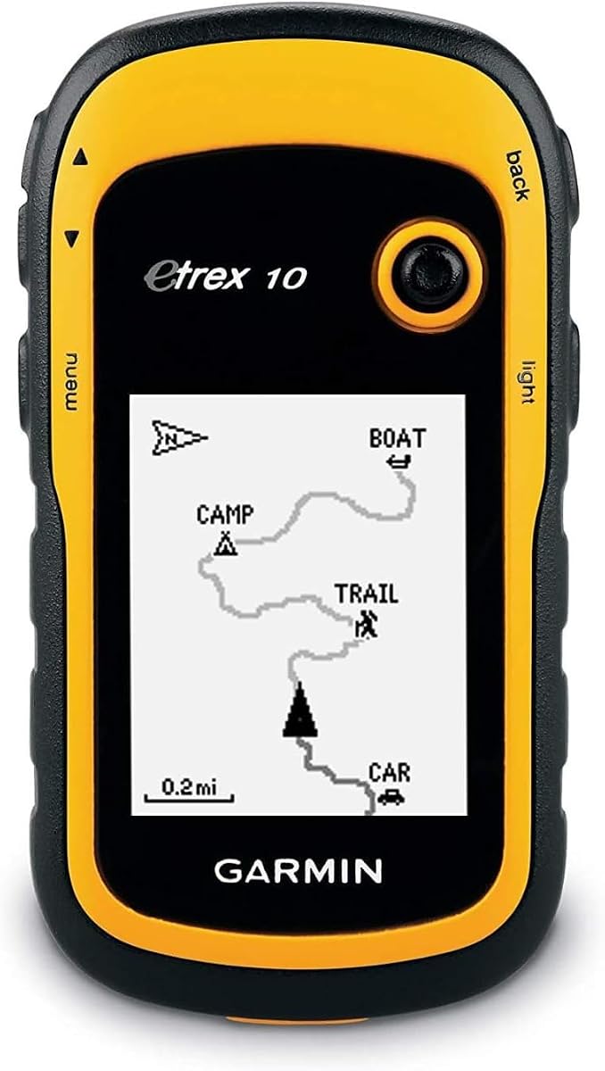
The Garmin eTrex 10 is a straightforward, rugged navigator for hunters who prioritize simplicity, worldwide mapping, and dependable operation over color-screen detail. Its 4.3 rating places it among the stronger-rated products here, while its WAAS-enabled GPS receiver, HotFix, and GLONASS support provide a capable positioning foundation.
We may earn a commission when you buy through this link, at no additional cost to you.
The preloaded worldwide basemap gives the device broad geographic coverage from the outset. Its 2.2-inch monochrome screen is easy to read in direct sun and works well with the traditional button interface. Paperless geocaching and Garmin spine mounting accessories add optional utility, while waypoint and elevation functions help users organize routes and review terrain points.
Waterproofing to IPX7 standards protects the eTrex 10 against rain, splashes, and general wet conditions. Two AA batteries provide up to 20 hours of use, with the listed guidance indicating that Polaroid AA batteries offer the best results. Compared with newer eTrex models, its monochrome display and older feature set provide less visual detail.
The eTrex 10 is best for hunters who need a dependable backup navigator, international travel, or a simple device for marked routes and waypoints. It is less suitable for buyers who need detailed topographic visualization, advanced satellite positioning, or a barometric altimeter. For straightforward remote navigation, however, its ruggedness and worldwide basemap are persuasive.
A worldwide basemap makes the eTrex 10 useful outside a single familiar region. Hunters can travel across borders or change hunting areas without relying on connectivity to display a basic road and terrain framework.
IPX7 waterproofing adds confidence during rain, stream crossings, and high-humidity environments. It remains a practical choice for users who prefer a simple handheld without a large screen.
We may earn a commission when you buy through this link, at no additional cost to you.
The Garmin eTrex SE combines a modern multi-GNSS receiver with one of the strongest power-management systems in this guide. Its 4.2 rating reflects favorable overall reception, and its ability to run for up to 1,800 hours in expedition mode makes it particularly compelling for remote hunters who cannot recharge often.
We may earn a commission when you buy through this link, at no additional cost to you.
The 2.2-inch high-resolution display is designed to remain readable in bright sunlight. Multi-GNSS support accesses GPS, GLONASS, Galileo, BeiDou, and QZSS, while a digital compass provides an accurate heading even when stationary. Field-replaceable AA batteries offer up to 168 hours in standard mode, with the batteries themselves not included.
Smartphone pairing adds another layer of utility through the Garmin Explore app. Compatible users can receive wireless software updates, plan trips, view Active Weather, obtain smart notifications, and access additional mapping. Automatic Geocaching Live updates can bring descriptions, logs, and hints to the handheld when paired through the app.
The eTrex SE is ideal for expeditions, backcountry bowhunting, and any outing where battery availability is uncertain. The water-resistant design carries an IPX7 rating and the rugged form remains suited to harsh conditions. Hunters wanting the simplest possible controls may prefer the eTrex 10, while those wanting even more satellite support can consider the GPSMAP 65.
Standard and expedition power modes offer striking flexibility. A hunter can use normal tracking for active days or switch to the longest-running mode when the priority is preserving the device for a prolonged wilderness trip.
Access to five major satellite-navigation systems can improve tracking options in challenging environments. It is a meaningful upgrade for hunters moving through dense vegetation, steep terrain, or areas where satellite visibility changes quickly.
We may earn a commission when you buy through this link, at no additional cost to you.
The Garmin Foretrex 701 Ballistic Edition is the most specialized hunting handheld in this guide. It carries the highest listed rating at 4.6 and separates itself through Applied Ballistics elite software, military-standard construction, and long-range shooting calculations. That makes it a serious option for rifle hunters who value more than basic navigation.
We may earn a commission when you buy through this link, at no additional cost to you.
Its 2-inch sunlight-readable display is compact, while the internal navigation sensors include a 3-axis accelerometer, 3-axis compass, and barometric altimeter. The device works with GPS, GLONASS, and Galileo systems. Smart notifications allow compatible phones to deliver emails, texts, and alerts, adding communication convenience without replacing the handheld's core role.
Durability is a major strength. The Foretrex 701 is constructed to MIL-STD-810G standards and is compatible with night-vision goggles, which is relevant to hunters who may operate around dawn, dusk, or in low-light field conditions. Its battery can exceed 48 hours in navigation mode, reach up to one week in UltraTrac mode, and last up to one month in watch mode.
This model is recommended for hunters who need ballistic calculations and can accept a smaller, more specialized interface. It is less broadly suited to hikers who primarily want detailed topographic maps or a touchscreen. For serious long-range hunting applications, though, the combination of ballistics, durable construction, sensors, and standby endurance is difficult to overlook.
Applied Ballistics elite software calculates aiming solutions for long-range shooting. That specialized functionality is the clearest reason to choose this model over a conventional hiking-oriented GPS handheld.
MIL-STD-810G construction and night-vision compatibility support demanding field use. The design is particularly relevant for hunters who travel before sunrise, remain active after sunset, or place a premium on equipment durability.
We may earn a commission when you buy through this link, at no additional cost to you.
The Garmin Oregon 700 brings touchscreen navigation to a rugged hunting handheld. Its 4.1 rating is the lowest among the numerically rated products in this list, but its 3-inch display, dual orientation, activity profiles, and expandable feature platform still make it a useful option for hunters who prefer direct map interaction.
We may earn a commission when you buy through this link, at no additional cost to you.
The sunlight-readable touchscreen can rotate between landscape and portrait views, helping users choose an orientation suited to maps, routes, or narrower trail conditions. A 240 by 400 resolution supports detailed reading. The device includes a tilt-compensated electronic compass, accelerometer, and barometric altimeter, giving it a useful group of navigation and environmental sensors.
The Oregon 700 is ruggedized against dust, dirt, and humidity and carries an IPX7 water rating. Its simplified multi-activity menu includes climb, hike, hunt, bike, geocache, and fish profiles. Connect IQ compatibility allows users to add data fields, widgets, and apps for a more personalized field interface.
The main drawback is battery life, listed at up to 16 hours, which is shorter than the endurance of most AA-powered devices here. It is a good choice for hunters who value a touchscreen and activity-specific menus over multi-week field endurance. Those planning extended remote trips should account for charging or choose a longer-running handheld.
A touchscreen makes it easier to pan, zoom, and inspect dense maps without navigating a complex physical keypad. Dual orientation further lets users tailor the display to the way they carry and view the device.
The built-in hunt profile provides a relevant starting point for hunting trips. Connect IQ support expands that foundation with custom fields, widgets, and applications for individual preferences.
We may earn a commission when you buy through this link, at no additional cost to you.
The Garmin GPSMAP H1 Premium is one of the most capable general-purpose hunting handhelds in this guide. It combines a large 3.5-inch color touchscreen with physical buttons, advanced positioning, extensive mapping, and a substantial accessory bundle. No numerical customer rating is supplied for this listing, so the evaluation focuses on its documented specifications.
We may earn a commission when you buy through this link, at no additional cost to you.
The scratch-resistant, sunlight-readable glass supports tapping, swiping, and zooming, while glove-friendly operation is part of the stated design. Physical buttons provide a dependable alternative in rain, snow, or rugged conditions, and a customizable quick-action button can open frequently used functions. A built-in LED flashlight and loud siren add useful emergency tools.
Multi-band GPS and multi-GNSS positioning are designed to improve accuracy in forests, valleys, and urban canyons. Built-in altimeter, barometer, and compass support awareness of direction, elevation, and pressure. The device claims up to 145 hours in GPS mode and up to 840 hours in Expedition mode with SatIQ, while the integrated mounting system and removable carabiner aid carrying.
This H1 bundle is appropriate for hunters who want a large, modern navigator, emergency tools, advanced positioning, and extended expedition options. The included power bank, charging adapters, cables, cleaning kit, and vehicle adapter make the package especially useful for remote travel. Those who only need basic navigation can find a lighter and more economical alternative among the eTrex models.
The hybrid interface allows detailed map work through the touchscreen without giving up tactile access to core controls. This is especially useful when conditions make touch interaction imprecise or when gloves limit dexterity.
A built-in flashlight and loud siren can assist in emergencies and low-light situations. Having those tools already integrated reduces the need to carry separate devices for basic signaling and illumination.
We may earn a commission when you buy through this link, at no additional cost to you.
This Garmin GPSMAP H1 Premium bundle offers the same core navigation platform as the other H1 listing but packages it with a different selection of charging and cleaning accessories. No numerical customer rating is provided, so its value should be assessed from the stated features rather than an established rating.
We may earn a commission when you buy through this link, at no additional cost to you.
The 3.5-inch color touchscreen uses scratch-resistant, sunlight-readable glass and is designed for glove-friendly tapping, swiping, and zooming. Physical buttons offer dependable operation in rain, snow, and rugged terrain, while a quick-action button can be customized for frequently used functions. The integrated mounting system and removable loop carabiner support different ways of carrying the unit.
Multi-band GPS, multi-GNSS support, and SatIQ technology form a strong positioning package for forests, deep valleys, and urban canyons. The altimeter, barometer, and compass provide additional field awareness. Preloaded TopoActive maps cover the United States, Canada, and Mexico, and high-resolution satellite imagery can be downloaded over Wi-Fi for planning.
The ruggedness specifications support demanding outdoor use, including MIL-STD 810 testing and an IP67 rating for water and dust resistance. With up to 145 hours in GPS mode and up to 840 hours in Expedition mode, it is designed for extended trips. Hunters who want maximal navigation detail and comprehensive carrying accessories will find this bundle particularly compelling.
Downloadable high-resolution imagery can help users study terrain features before entering an unfamiliar hunting area. Wi-Fi transfer support also creates a practical bridge between online planning and offline field navigation.
The IP67 rating and MIL-STD 810 testing support use in wet, dusty, and demanding environments. Integrated mounting hardware and a removable carabiner make it easier to keep the device accessible while moving or setting up camp.
We may earn a commission when you buy through this link, at no additional cost to you.
The Garmin Montana 600 prioritizes map readability with a bright 4-inch sunlight-readable color touchscreen, making it the largest display among the listed products. Its 4.2 rating indicates a generally positive reception, and the touchscreen, compass, altimeter, and waterproof construction give it appeal for hunters who want clear visual navigation.
We may earn a commission when you buy through this link, at no additional cost to you.
The large color screen makes it easier to inspect terrain details, route lines, and surrounding geography without frequent zooming. A high-sensitivity WAAS-enabled GPS receiver supports position acquisition, while the 3-axis compass and barometric altimeter add navigation context beyond a basic coordinate display.
As a hiking GPS, the Montana 600 is oriented toward users who want a conventional consumer-style handheld rather than a compact eTrex. Its larger body may be less convenient for hunters who prefer minimal pack weight or a device that can be operated entirely through small physical buttons. It also belongs to an older product generation with less advanced multi-GNSS information than the newest models here.
The Montana 600 is best for hunters who prioritize a large, bright touchscreen and immediate visual access to maps. It is especially useful at a basecamp, vehicle, or stationary observation point where the extra screen size is easier to appreciate. Active hunters seeking advanced satellite support, modern emergency features, or longer expedition battery options should examine the GPSMAP 65 or GPSMAP H1 instead.
The 4-inch color display provides more room to understand the landscape without constant zooming. That visual advantage is useful for navigating around unfamiliar ridges, drainage systems, and road networks.
A 3-axis compass and barometric altimeter complement the WAAS-enabled receiver. These sensors make the Montana 600 useful for stationary orientation and for monitoring elevation during a route.
We may earn a commission when you buy through this link, at no additional cost to you.
The most useful hunting GPS is the one that remains reliable on the terrain, routes, and trip length you actually expect. Consider positioning, maps, display visibility, controls, sensors, durability, battery life, and hunting-specific functions before choosing a model.
Satellite support determines how consistently a handheld can fix your position in the places you hunt. Basic GPS-only devices remain useful, but models supporting multiple systems can offer additional options when visibility is limited. The eTrex SE supports GPS, GLONASS, Galileo, BeiDou, and QZSS, while the eTrex 22x and eTrex 32x list GPS and GLONASS. The GPSMAP 65 and GPSMAP H1 Premium add multi-band positioning for demanding locations such as steep country, urban canyons, and dense forests.
Choose broader satellite and multi-band support when your hunting area has heavy canopy, sharp elevation changes, or repeated transitions between open and obstructed terrain.
Maps should show more than a coordinate marker if you plan to navigate without paper backups. Topo Active mapping on the eTrex 22x, eTrex 32x, GPSMAP 65, and GPSMAP H1 models includes terrain-oriented content, while the eTrex 10 supplies a worldwide basemap. The H1 listings also support downloadable high-resolution satellite imagery for the United States, Canada, and Mexico.
Match map coverage to the region and style of your hunt, and verify whether additional regional content requires a download or compatible subscription.
Screen size affects how much terrain can be interpreted at once. The 2-inch Foretrex 701 and 2.2-inch eTrex devices prioritize compactness, while the Oregon 700 provides a 3-inch touchscreen and the Montana 600 reaches 4 inches. The GPSMAP H1 uses a 3.5-inch display. All listed color screens are described as sunlight readable, which matters more for hunting than maximum brightness or decorative screen quality.
Choose a compact display for mobility, or a larger screen when basecamp use, map interpretation, and route overview are more important.
Wet hands, cold fingers, and gloves can make a touchscreen frustrating to operate. The eTrex 10, eTrex 22x, eTrex 32x, eTrex SE, GPSMAP 65, and Foretrex 701 emphasize physical buttons. The Oregon 700, Montana 600, and GPSMAP H1 models prioritize touch interaction, while the H1 also provides physical buttons and a customizable quick-action control for a hybrid approach.
Favor tactile buttons for active travel and fast maneuvers. Choose a touchscreen for detailed map exploration, and consider a hybrid model if your priorities include both.
Battery expectations should be based on how long the device must operate away from a vehicle or charging point. The eTrex 22x and eTrex 32x list up to 25 hours in GPS mode, while the eTrex 10 offers up to 20 hours. The eTrex SE can run for up to 168 hours in standard mode and 1,800 hours in expedition mode. The Foretrex 701 provides exceptional standby and watch-mode endurance, and the GPSMAP H1 lists up to 145 hours in GPS mode and 840 hours in expedition mode.
Consider both active tracking time and low-power expedition performance. More demanding screens, wireless connectivity, and advanced positioning can affect real-world results, so plan charging accordingly.
A compass provides an immediate heading even when the user is standing still, while a barometric altimeter adds elevation context. The eTrex 32x, Oregon 700, Montana 600, and Foretrex 701 list both a 3-axis compass and barometric altimeter. The GPSMAP H1 also includes an altimeter, barometer, and compass. Hunters who expect to navigate from a stand, use ridgelines, or monitor changing elevation should give these features careful consideration.
Choose a model with compass and altimeter sensors when direction without movement and terrain awareness are central to your navigation style.
Hunting handhelds are exposed to rain, mud, dust, cold, and repeated impacts. The eTrex 10, eTrex SE, and Oregon 700 carry IPX7 ratings, while the Foretrex 701 is constructed to MIL-STD-810G standards. The GPSMAP H1 listings list MIL-STD 810 testing and an IP67 rating for water and dust resistance. A rugged mount, carabiner, or included carrying accessories can also reduce the chance of drops.
For remote or wet hunting country, prioritize a documented water rating and rugged construction over aesthetic refinements.
Hunting-specific tools can be more valuable than general multimedia features. The Foretrex 701 includes Applied Ballistics elite software for long-range shooting, and the Oregon 700 provides a dedicated hunt activity profile. Smart notifications appear on the Foretrex 701, while Garmin Explore connectivity on several models supports track, route, waypoint, and weather management. Decide whether ballistics, custom activity fields, or geocaching functions align with your actual hunting plans.
Buy specialized features when they will be used regularly. A simpler navigator often serves general hunters better than a device loaded with functions that do not improve their routes or field decisions.
Before the trip, update the handheld's software and maps, confirm that the maps cover the entire hunting area, and review the route offline. Enter key waypoints before leaving coverage, create a realistic battery plan, and pack spare batteries if the model uses AA cells. It is also useful to practice the controls at home, including switching orientation, starting a track, marking a waypoint, and using the compass or altimeter.
While hunting, confirm the position fix before relying on a route, use the map and compass together, and avoid assuming that a displayed course line accounts for every obstruction or terrain hazard. Keep the unit attached to a belt, chest, pack, or compatible mount rather than carrying it loose. Follow the manufacturer's guidance for charging, storage, and permitted accessories, particularly for models with included power banks or adapters.
After the outing, clean dirt and mud from the controls and charging ports, then allow the device to dry before storing it in a sealed bag. Remove batteries from models that use them during prolonged storage, inspect the mount and carry hardware, and download any recorded tracks or field notes. Periodic software and map updates help preserve navigation reliability, while a fresh battery check before each trip prevents avoidable failures.
It depends on how and where the device is used. Touchscreens provide faster panning, zooming, and detailed map inspection, which can be useful during planning or at a basecamp. Physical buttons are often easier to operate precisely with wet hands, cold fingers, or gloves. Hybrid models such as the GPSMAP H1 offer both approaches and may be the most versatile option for active hunters.
Multi-band positioning is most valuable in places where a standard receiver can become less consistent, including dense forests, steep terrain, deep valleys, and urban canyons. It is not essential for every hunt, but it can provide valuable redundancy when accurate positioning is critical. The GPSMAP 65 and GPSMAP H1 are the choices in this guide with documented multi-band technology.
The appropriate runtime depends on trip length, screen use, satellite features, temperature, and battery type. Multi-day users should consider models with strong expedition modes or carry spare batteries, while shorter trips may be comfortable with a conventional AA-powered handheld. Always compare the documented active mode with low-power mode and plan for reduced performance in cold conditions.
Downloadable maps are strongly recommended for backcountry hunting because they remain available without cellular service and can provide terrain context before a trip. Models with microSD slots or internal storage are more flexible, but users must confirm regional compatibility and download maps before leaving. A preloaded worldwide basemap is useful for broad orientation, while detailed topographic coverage is preferable for route planning.
A handheld is not a substitute for safe planning, appropriate navigation skills, weather awareness, or a reliable emergency plan. It can reduce navigation uncertainty, store waypoints and routes, show terrain information, and help hunters monitor position and elevation. Users should still carry the appropriate backup equipment and remain prepared to turn around if conditions exceed their skill or equipment limits.
The Garmin Foretrex 701 Ballistic Edition is the most purpose-built choice in this list because Applied Ballistics elite software calculates aiming solutions for long-range shooting. Hunters should still verify their rifle, ammunition, optic, environmental assumptions, and appropriate zero before relying on any calculated solution. Ballistic features support planning but do not replace sound judgment or practice.
The eTrex models in this guide generally emphasize compact construction, physical buttons, and AA-battery convenience, while the GPSMAP models offer larger or more advanced positioning systems. The GPSMAP 65 uses multi-band positioning and a 2.6-inch color screen, while the GPSMAP H1 adds a 3.5-inch hybrid touchscreen interface, flashlight, siren, and extensive expedition features. Both families can serve hunters well.
Yes. Standalone models such as the eTrex 10, eTrex 22x, eTrex 32x, eTrex SE, GPSMAP 65, Foretrex 701, and Montana 600 can perform their core navigation functions without a phone. Smartphone pairing adds planning, updates, notifications, weather information, and geocaching content, but it should not be assumed that every feature depends on connectivity.
The Garmin GPSMAP 65 is the strongest all-around recommendation for hunters who need advanced positioning, topographic mapping, and dependable physical controls. The eTrex 22x is a compelling budget-oriented choice for straightforward navigation, while the Foretrex 701 stands apart for long-range ballistics, military-grade construction, and exceptional standby endurance. Each serves a different style of hunt rather than one universal set of priorities.
Before choosing, match the navigator to your terrain, trip length, and operating style. Favor multi-band and multi-GNSS support beneath dense canopy, prioritize compass and altimeter data for stationary orientation, and choose a larger touchscreen when detailed map exploration matters. Conversely, AA models with long GPS runtimes can be more dependable for remote trips where charging opportunities are limited.
Finally, confirm the current product listing, regional map coverage, included accessories, battery requirements, and compatibility details before buying. Product configurations and availability can change, and ratings may shift as more owners submit feedback. A careful fit based on actual hunting conditions will provide more value than choosing on screen size or feature count alone.
